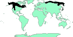
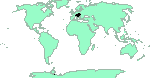
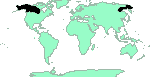
 -. See [maps]
Melissa Arctic
-. See [maps]
Melissa Arctic
Larva on Poaceae , Cyperaceae [NAB]
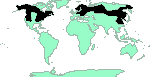
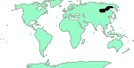
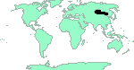
 S.Siberia, N.Mongolia. See [maps]
 E.Kazakhstan (Tarbagatai, Saur Mts.). See [maps]
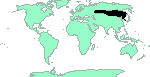
 . See [maps]
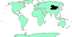
Baltic Grayling
Jutta Arctic
Mszarnik jutta
Gråbrun gräsfjäril
Juttafjäril
Rämekylmäperhonen
. See [maps]
Baltic Grayling
Jutta Arctic
Mszarnik jutta
Gråbrun gräsfjäril
Juttafjäril
Rämekylmäperhonen
![[jutta-1v.jpg]](jutta-1v.jpg) 500x506 (~54Kb) underside Finland, Pihtipudas, Liitonjärvi, 703:44, 30.6.1996, Photo © Tero Piirainen
500x506 (~54Kb) underside Finland, Pihtipudas, Liitonjärvi, 703:44, 30.6.1996, Photo © Tero Piirainen
|
![[jutta.jpg]](jutta.jpg) 596x854 (~132Kb)
596x854 (~132Kb)
|
Larva on Eriphorum , Carex , Scirpus caespitosa, Molinia caerulea, Glyceria , Juncus [BRU], Eriophorum spissum? [NAB]
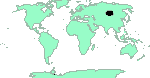
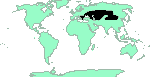
 Altai - S.Siberia - Far East, Amur, Mongolia, N.China. See [maps]
![[dubia-1mv.jpg]](dubia-1mv.jpg) 531x500 (~60Kb) ♂ underside A subalpine larch parkland on the southern principle slope of the Yuzhno-Chuiskii mountain range between the Chikty and Akbul Rivulets, 2300 m above sea level, the upper Dzhazator River basin, Kosh-Agach District, Altai Republic, West Siberia, Russia. 11th July 1998 (on Geranium krylovii Tzvelev, 1993), Photo © Oleg Kosterin
531x500 (~60Kb) ♂ underside A subalpine larch parkland on the southern principle slope of the Yuzhno-Chuiskii mountain range between the Chikty and Akbul Rivulets, 2300 m above sea level, the upper Dzhazator River basin, Kosh-Agach District, Altai Republic, West Siberia, Russia. 11th July 1998 (on Geranium krylovii Tzvelev, 1993), Photo © Oleg Kosterin
|
![[dubia-1v.jpg]](dubia-1v.jpg) 616x700 (~138Kb) underside A subalpine larch parkland on the southern principle slope of the Yuzhno-Chuiskii mountain range between the Chikty and Akbul Rivulets, 2300 m above sea level, the upper Dzhazator River basin, Kosh-Agach District, Altai Republic, West Siberia, Russia. 11th July 1998, Photo © Oleg Kosterin
616x700 (~138Kb) underside A subalpine larch parkland on the southern principle slope of the Yuzhno-Chuiskii mountain range between the Chikty and Akbul Rivulets, 2300 m above sea level, the upper Dzhazator River basin, Kosh-Agach District, Altai Republic, West Siberia, Russia. 11th July 1998, Photo © Oleg Kosterin
|
![[dubia-2va.jpg]](dubia-2va.jpg) 1093x861 (~372Kb) underside A dry open Pinus sibirica Du Tour stand on a rocky granite ridge between the Akkem and Aryskan Rivers 2300 m above sea level, the Akkem River basin, the Katunskii Range northern principal slope, Central [Russian] Altai Mts., Ust'-Koksa District, Altai Republic, West Siberia, Russia. 4th July 2007, Photo © Oleg Kosterin
1093x861 (~372Kb) underside A dry open Pinus sibirica Du Tour stand on a rocky granite ridge between the Akkem and Aryskan Rivers 2300 m above sea level, the Akkem River basin, the Katunskii Range northern principal slope, Central [Russian] Altai Mts., Ust'-Koksa District, Altai Republic, West Siberia, Russia. 4th July 2007, Photo © Oleg Kosterin
|
![[dubia-2vx.jpg]](dubia-2vx.jpg) 918x1224 (~703Kb) underside A dry open Pinus sibirica Du Tour stand on a rocky granite ridge between the Akkem and Aryskan Rivers 2300 m above sea level, the Akkem River basin, the Katunskii Range northern principal slope, Central [Russian] Altai Mts., Ust'-Koksa District, Altai Republic, West Siberia, Russia. 4th July 2007, Photo © Oleg Kosterin
918x1224 (~703Kb) underside A dry open Pinus sibirica Du Tour stand on a rocky granite ridge between the Akkem and Aryskan Rivers 2300 m above sea level, the Akkem River basin, the Katunskii Range northern principal slope, Central [Russian] Altai Mts., Ust'-Koksa District, Altai Republic, West Siberia, Russia. 4th July 2007, Photo © Oleg Kosterin
|
![[dubia-2vy.jpg]](dubia-2vy.jpg) 1224x918 (~783Kb) underside A dry open Pinus sibirica Du Tour stand on a rocky granite ridge between the Akkem and Aryskan Rivers 2300 m above sea level, the Akkem River basin, the Katunskii Range northern principal slope, Central [Russian] Altai Mts., Ust'-Koksa District, Altai Republic, West Siberia, Russia. 4th July 2007, Photo © Oleg Kosterin
1224x918 (~783Kb) underside A dry open Pinus sibirica Du Tour stand on a rocky granite ridge between the Akkem and Aryskan Rivers 2300 m above sea level, the Akkem River basin, the Katunskii Range northern principal slope, Central [Russian] Altai Mts., Ust'-Koksa District, Altai Republic, West Siberia, Russia. 4th July 2007, Photo © Oleg Kosterin
|
![[dubia-2vz.jpg]](dubia-2vz.jpg) 1167x918 (~531Kb) underside A dry open Pinus sibirica Du Tour stand on a rocky granite ridge between the Akkem and Aryskan Rivers 2300 m above sea level, the Akkem River basin, the Katunskii Range northern principal slope, Central [Russian] Altai Mts., Ust'-Koksa District, Altai Republic, West Siberia, Russia. 4th July 2007, Photo © Oleg Kosterin
1167x918 (~531Kb) underside A dry open Pinus sibirica Du Tour stand on a rocky granite ridge between the Akkem and Aryskan Rivers 2300 m above sea level, the Akkem River basin, the Katunskii Range northern principal slope, Central [Russian] Altai Mts., Ust'-Koksa District, Altai Republic, West Siberia, Russia. 4th July 2007, Photo © Oleg Kosterin
|
 Alps. See [maps]
Gletscherfalter
Alpine Grayling
Alps. See [maps]
Gletscherfalter
Alpine Grayling
Larva on Festuca ovina [H&R]
 Lappland, N.Siberia (polar tundra), Altai, Targbagatai, Japan, Circumpolar?. See [maps]
Norse Grayling
Nornafjäril
Gulbrun Gräsfjäril
Sarakylmäperhonen
Lappland, N.Siberia (polar tundra), Altai, Targbagatai, Japan, Circumpolar?. See [maps]
Norse Grayling
Nornafjäril
Gulbrun Gräsfjäril
Sarakylmäperhonen
![[norna-1v.jpg]](norna-1v.jpg) 891x560 (~121Kb) underside Stony bank of the Chikty Rivulet among alpine meadow/dwarf birch thickets, 2500 m above sea level, the southern principle slope of the Yuzhno-Chuiskii mountain range, the upper Dzhazator River basin, Kosh-Agach District, Altai Republic, West Siberia, Russia. 13th July 1998, Photo © Oleg Kosterin
891x560 (~121Kb) underside Stony bank of the Chikty Rivulet among alpine meadow/dwarf birch thickets, 2500 m above sea level, the southern principle slope of the Yuzhno-Chuiskii mountain range, the upper Dzhazator River basin, Kosh-Agach District, Altai Republic, West Siberia, Russia. 13th July 1998, Photo © Oleg Kosterin
|
![[norna.jpg]](norna.jpg) 509x653 (~65Kb)
509x653 (~65Kb)
|
Larva on Carex , Nardus , Poa [BRU]
![[altaica-1mv.jpg]](altaica-1mv.jpg) 566x551 (~59Kb) ♂ underside An alpine meadow in the valley of the left headwater of the Chikty Rivulet, 2600 m above sea level, the southern principle slope of the Yuzhno-Chuiskii mountain range, the upper Dzhazator River basin, Kosh-Agach District, Altai Republic, West Siberia, Russia. 9th July 1998 (on of Angelica archangelica), Photo © Oleg Kosterin
566x551 (~59Kb) ♂ underside An alpine meadow in the valley of the left headwater of the Chikty Rivulet, 2600 m above sea level, the southern principle slope of the Yuzhno-Chuiskii mountain range, the upper Dzhazator River basin, Kosh-Agach District, Altai Republic, West Siberia, Russia. 9th July 1998 (on of Angelica archangelica), Photo © Oleg Kosterin
|
![[altaica-1mvx.jpg]](altaica-1mvx.jpg) 617x574 (~80Kb) ♂ underside An alpine meadow in the valley of the left headwater of the Chikty Rivulet, 2600 m above sea level, the southern principle slope of the Yuzhno-Chuiskii mountain range, the upper Dzhazator River basin, Kosh-Agach District, Altai Republic, West Siberia, Russia. 9th July 1998 (on Lagotis integrifolia), Photo © Oleg Kosterin
617x574 (~80Kb) ♂ underside An alpine meadow in the valley of the left headwater of the Chikty Rivulet, 2600 m above sea level, the southern principle slope of the Yuzhno-Chuiskii mountain range, the upper Dzhazator River basin, Kosh-Agach District, Altai Republic, West Siberia, Russia. 9th July 1998 (on Lagotis integrifolia), Photo © Oleg Kosterin
|
![[altaica-1mvy.jpg]](altaica-1mvy.jpg) 823x596 (~121Kb) ♂ underside An alpine meadow in the valley of the left headwater of the Chikty Rivulet, 2600 m above sea level, the southern principle slope of the Yuzhno-Chuiskii mountain range, the upper Dzhazator River basin, Kosh-Agach District, Altai Republic, West Siberia, Russia. 11th July 1998 (on horse dung), Photo © Oleg Kosterin
823x596 (~121Kb) ♂ underside An alpine meadow in the valley of the left headwater of the Chikty Rivulet, 2600 m above sea level, the southern principle slope of the Yuzhno-Chuiskii mountain range, the upper Dzhazator River basin, Kosh-Agach District, Altai Republic, West Siberia, Russia. 11th July 1998 (on horse dung), Photo © Oleg Kosterin
|
![[altaica-1mvz.jpg]](altaica-1mvz.jpg) 516x392 (~40Kb) ♂ underside An alpine meadow in the valley of the left headwater of the Chikty Rivulet, 2600 m above sea level, the southern principle slope of the Yuzhno-Chuiskii mountain range, the upper Dzhazator River basin, Kosh-Agach District, Altai Republic, West Siberia, Russia. 11th July 1998 (on horse dung), Photo © Oleg Kosterin
516x392 (~40Kb) ♂ underside An alpine meadow in the valley of the left headwater of the Chikty Rivulet, 2600 m above sea level, the southern principle slope of the Yuzhno-Chuiskii mountain range, the upper Dzhazator River basin, Kosh-Agach District, Altai Republic, West Siberia, Russia. 11th July 1998 (on horse dung), Photo © Oleg Kosterin
|
![[altaica-2v.jpg]](altaica-2v.jpg) 887x1070 (~500Kb) underside An alpine meadow patch neighbouring with the most elevated larch wood outposts in the Kamdyt valley, a Tekelyu River right tributary which in turn is an Akkem River right tributary, the Katunskii Range northern principal slope, Central [Russian] Altai Mts., Ust'-Koksa District, Altai Rapublic, West Siberia, Russia. 4rd July 2007, Photo © Oleg Kosterin
887x1070 (~500Kb) underside An alpine meadow patch neighbouring with the most elevated larch wood outposts in the Kamdyt valley, a Tekelyu River right tributary which in turn is an Akkem River right tributary, the Katunskii Range northern principal slope, Central [Russian] Altai Mts., Ust'-Koksa District, Altai Rapublic, West Siberia, Russia. 4rd July 2007, Photo © Oleg Kosterin
|
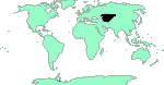
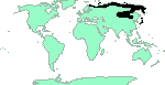
 -. See [maps]
 -. See [maps]
Katahdin Arctic
Polixenes Arctic
-. See [maps]
Katahdin Arctic
Polixenes Arctic
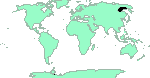
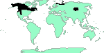
 N.British Columbia, Yukon, Northwest Territories, Alaska. See [maps]
Larva on Eriophorum [RFEL]
 Chukot, Magadan, Alaska. See [maps]
 N.Transbaikalia, Yakutia. See [maps]
E.Kasakhstan (Saur, Tarbagatai, Monrak Mts.). See [maps]
N.Transbaikalia, Yakutia. See [maps]
E.Kasakhstan (Saur, Tarbagatai, Monrak Mts.). See [maps]
 -. See [maps]
 Kirgizia (Alai, Trans-Alai, Kirghiztan Mts., Tian Shan), Tajikistan (Trans-Alai, N.Pamir), Uzbekistan (Tian Shan), Kazakhstan (Ketmen Mts., Kungey and Transili Alatau), W.China (Boro-Choro Mts., E.Tian Shan). See [maps]
 -. See [maps]
 -. See [maps]
![[ammon-1fv.jpg]](ammon-1fv.jpg) 777x747 (~133Kb) ♀ underside An alpine meadow in the valley of a headwater of the Chikty Rivulet, 2500 m above sea level, the southern principle slope of the Yuzhno-Chuiskii mountain range, the upper Dzhazator River basin, Kosh-Agach District, Altai Republic, West Siberia, Russia. 15th July 1998, Photo © Oleg Kosterin
777x747 (~133Kb) ♀ underside An alpine meadow in the valley of a headwater of the Chikty Rivulet, 2500 m above sea level, the southern principle slope of the Yuzhno-Chuiskii mountain range, the upper Dzhazator River basin, Kosh-Agach District, Altai Republic, West Siberia, Russia. 15th July 1998, Photo © Oleg Kosterin
|
![[ammon-1mv.jpg]](ammon-1mv.jpg) 738x636 (~133Kb) ♂ underside An alpine meadow in the valley of a headwater of the Chikty Rivulet, 2500 m above sea level, the southern principle slope of the Yuzhno-Chuiskii mountain range, the upper Dzhazator River basin, Kosh-Agach District, Altai Republic, West Siberia, Russia. 15th July 1998, Photo © Oleg Kosterin
738x636 (~133Kb) ♂ underside An alpine meadow in the valley of a headwater of the Chikty Rivulet, 2500 m above sea level, the southern principle slope of the Yuzhno-Chuiskii mountain range, the upper Dzhazator River basin, Kosh-Agach District, Altai Republic, West Siberia, Russia. 15th July 1998, Photo © Oleg Kosterin
|
 . See [maps]
Arctic Greyling
Borefjäril
Grågul Gräsfjäril
Paljakkakylmäperhonen
Arctic Greyling
. See [maps]
Arctic Greyling
Borefjäril
Grågul Gräsfjäril
Paljakkakylmäperhonen
Arctic Greyling
![[bore-1v.jpg]](bore-1v.jpg) 600x506 (~57Kb) underside FINLAND: Li: Utsjoki Puollamoaivi, 775:50, 8.7.1997, Photo © Markku Savela
600x506 (~57Kb) underside FINLAND: Li: Utsjoki Puollamoaivi, 775:50, 8.7.1997, Photo © Markku Savela
|
![[bore.jpg]](bore.jpg) 464x632 (~54Kb)
464x632 (~54Kb)
|
Larva on Festuca ovina, Carex [BRU]
Larva on Poaceae ?, Cyperaceae ? [NAB]
Yakutia, Magadan. See [maps]
 Vancouver - California. See [maps]
Great Arctic
Nevada Arctic
Vancouver - California. See [maps]
Great Arctic
Nevada Arctic
![[nevadensis-1f.jpg]](nevadensis-1f.jpg) 600x668 (~78Kb) ♀ USA: FR 9711, Hurley Creek (47°18'31N 120°36'56W), Kittitas Co., WA, 5.7.2000, Photo © Markku Savela
600x668 (~78Kb) ♀ USA: FR 9711, Hurley Creek (47°18'31N 120°36'56W), Kittitas Co., WA, 5.7.2000, Photo © Markku Savela
|
![[nevadensis-1fv.jpg]](nevadensis-1fv.jpg) 700x889 (~120Kb) ♀ underside USA: FR 9711, Hurley Creek (47°18'31N 120°36'56W), Kittitas Co., WA, 5.7.2000, Photo © Markku Savela
700x889 (~120Kb) ♀ underside USA: FR 9711, Hurley Creek (47°18'31N 120°36'56W), Kittitas Co., WA, 5.7.2000, Photo © Markku Savela
|
![[nevadensis-2mv.jpg]](nevadensis-2mv.jpg) 640x649 (~79Kb) ♂ underside USA: FR 9711, (47°18'23N 120°36'31W), Kittitas Co., WA, 7.7.2000, Photo © Markku Savela
640x649 (~79Kb) ♂ underside USA: FR 9711, (47°18'23N 120°36'31W), Kittitas Co., WA, 7.7.2000, Photo © Markku Savela
|
![[nevadensis-3mu.jpg]](nevadensis-3mu.jpg) 1100x1050 (~173Kb) ♂ upperside USA: Washington, Chelan Co., LepSoc 2010 Field Trip (Eagle Creek ?), 11.7.2010, Photo © Markku Savela
1100x1050 (~173Kb) ♂ upperside USA: Washington, Chelan Co., LepSoc 2010 Field Trip (Eagle Creek ?), 11.7.2010, Photo © Markku Savela
|
||
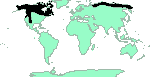
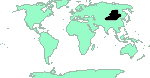
 British Columbia, Alberta, S.Northwest Territories, Saskatchewan, Manitoba, Ontario, Quebec, Minnesota, Michigan. See [maps]
Canada Arctic
Macoun's Arctic
British Columbia, Alberta, S.Northwest Territories, Saskatchewan, Manitoba, Ontario, Quebec, Minnesota, Michigan. See [maps]
Canada Arctic
Macoun's Arctic
![[macounii-1mu.jpg]](macounii-1mu.jpg) 1600x1200 (~288Kb) ♂ upperside Assiniboine, AB, 4.VI.1995, Photo 2004 © Joseph Belicek
1600x1200 (~288Kb) ♂ upperside Assiniboine, AB, 4.VI.1995, Photo 2004 © Joseph Belicek
|
![[macounii-1mv.jpg]](macounii-1mv.jpg) 1600x1200 (~256Kb) ♂ underside Assiniboine, AB, 4.VI.1995, Photo 2004 © Joseph Belicek
1600x1200 (~256Kb) ♂ underside Assiniboine, AB, 4.VI.1995, Photo 2004 © Joseph Belicek
|
 -. See [maps]
Chryxus Arctic
-. See [maps]
Chryxus Arctic
Larva on Poaceae , Festuca idahoensis? [NAB]
 -. See [maps]
Alberta Arctic
-. See [maps]
Alberta Arctic
Larva on Poaceae , Festuca [NAB]
 -. See [maps]
Uhler's Arctic
-. See [maps]
Uhler's Arctic
 -. See [maps]
![[sculda-1fv.jpg]](sculda-1fv.jpg) 730x725 (~141Kb) ♀ underside An alpine meadow in the valley of the left headwater of the Chikty Rivulet, 2600 m above sea level, the southern principle slope of the Yuzhno-Chuiskii mountain range, the upper Dzhazator River basin, Kosh-Agach District, Altai Republic, West Siberia, Russia. 10th July 1998, Photo © Oleg Kosterin
730x725 (~141Kb) ♀ underside An alpine meadow in the valley of the left headwater of the Chikty Rivulet, 2600 m above sea level, the southern principle slope of the Yuzhno-Chuiskii mountain range, the upper Dzhazator River basin, Kosh-Agach District, Altai Republic, West Siberia, Russia. 10th July 1998, Photo © Oleg Kosterin
|
![[sculda-2fv.jpg]](sculda-2fv.jpg) 1052x979 (~356Kb) ♀ underside An alpine meadow patch neighbouring with the most elevated larch wood outposts in the Kamdyt valley, a Tekelyu River right tributary which in turn is an Akkem River right tributary, the Katunskii Range northern principal slope, Central [Russian] Altai Mts., Ust'-Koksa District, Altai Rapublic, West Siberia, Russia. 3th July 2007, Photo © Oleg Kosterin
1052x979 (~356Kb) ♀ underside An alpine meadow patch neighbouring with the most elevated larch wood outposts in the Kamdyt valley, a Tekelyu River right tributary which in turn is an Akkem River right tributary, the Katunskii Range northern principal slope, Central [Russian] Altai Mts., Ust'-Koksa District, Altai Rapublic, West Siberia, Russia. 3th July 2007, Photo © Oleg Kosterin
|
 -. See [maps]
![[nanna-1fv.jpg]](nanna-1fv.jpg) 880x722 (~181Kb) ♀ underside A meadowy SW slope of a ridge between the headwaters of the Chikty Rivulet, 2700 m above sea level, the southern principle slope of the Yuzhno-Chuiskii mountain range, the upper Dzhazator River basin, Kosh-Agach District, Altai Republic, West Siberia, Russia. 10th July 1998, Photo © Oleg Kosterin
880x722 (~181Kb) ♀ underside A meadowy SW slope of a ridge between the headwaters of the Chikty Rivulet, 2700 m above sea level, the southern principle slope of the Yuzhno-Chuiskii mountain range, the upper Dzhazator River basin, Kosh-Agach District, Altai Republic, West Siberia, Russia. 10th July 1998, Photo © Oleg Kosterin
|
![[nanna-1mv.jpg]](nanna-1mv.jpg) 600x912 (~175Kb) ♂ underside A dry rocky southern slope of a ridge between the headwaters of the Chikty Rivulet, 2700 m above sea level, the southern principle slope of the Yuzhno-Chuiskii mountain range, the upper Dzhazator River basin, Kosh-Agach District, Altai Republic, West SIberia, Russia. 10th July 1998, Photo © Oleg Kosterin
600x912 (~175Kb) ♂ underside A dry rocky southern slope of a ridge between the headwaters of the Chikty Rivulet, 2700 m above sea level, the southern principle slope of the Yuzhno-Chuiskii mountain range, the upper Dzhazator River basin, Kosh-Agach District, Altai Republic, West SIberia, Russia. 10th July 1998, Photo © Oleg Kosterin
|
![[nanna-1mvx.jpg]](nanna-1mvx.jpg) 412x566 (~85Kb) ♂ underside A dry rocky southern slope of a ridge between the headwaters of the Chikty Rivulet, 2700 m above sea level, the southern principle slope of the Yuzhno-Chuiskii mountain range, the upper Dzhazator River basin, Kosh-Agach District, Altai Republic, West SIberia, Russia. 10th July 1998, Photo © Oleg Kosterin
412x566 (~85Kb) ♂ underside A dry rocky southern slope of a ridge between the headwaters of the Chikty Rivulet, 2700 m above sea level, the southern principle slope of the Yuzhno-Chuiskii mountain range, the upper Dzhazator River basin, Kosh-Agach District, Altai Republic, West SIberia, Russia. 10th July 1998, Photo © Oleg Kosterin
|
![[nanna-1mvy.jpg]](nanna-1mvy.jpg) 826x859 (~252Kb) ♂ underside A dry rocky southern slope of a ridge between the headwaters of the Chikty Rivulet, 2700 m above sea level, the southern principle slope of the Yuzhno-Chuiskii mountain range, the upper Dzhazator River basin, Kosh-Agach District, Altai Republic, West Siberia, Russia. 10th July 1998, Photo © Oleg Kosterin
826x859 (~252Kb) ♂ underside A dry rocky southern slope of a ridge between the headwaters of the Chikty Rivulet, 2700 m above sea level, the southern principle slope of the Yuzhno-Chuiskii mountain range, the upper Dzhazator River basin, Kosh-Agach District, Altai Republic, West Siberia, Russia. 10th July 1998, Photo © Oleg Kosterin
|
||
C.Tuva, Sayan. See [maps]
 -. See [maps]
![[albidior-1mv.jpg]](albidior-1mv.jpg) 533x400 (~40Kb) ♂ underside An open pine forest on the hill just north of the Chita City, Transbaikalia, Siberia, Russia. 17th June 1995, Photo © Oleg Kosterin
533x400 (~40Kb) ♂ underside An open pine forest on the hill just north of the Chita City, Transbaikalia, Siberia, Russia. 17th June 1995, Photo © Oleg Kosterin
|
 -. See [maps]
 -. See [maps]
![[tarpeia-1v.jpg]](tarpeia-1v.jpg) 486x392 (~47Kb) underside A steppen rocky southern slope of the hill Sopka Mokhnataya of the hill chain called Bugotakskie Sopki, Toguchin District, Novosibirsk Province, Russia. 12th June 1995, Photo © Oleg Kosterin
486x392 (~47Kb) underside A steppen rocky southern slope of the hill Sopka Mokhnataya of the hill chain called Bugotakskie Sopki, Toguchin District, Novosibirsk Province, Russia. 12th June 1995, Photo © Oleg Kosterin
|
![[tarpeia-2afv.jpg]](tarpeia-2afv.jpg) 1307x998 (~233Kb) ♀ underside A patch of a Festuca valesiaca/Carex praecox steppe at birch groves at Podgorodka, Omsk District and Province, West Siberia, Russia 7th June 2004, Photo © Oleg Kosterin
1307x998 (~233Kb) ♀ underside A patch of a Festuca valesiaca/Carex praecox steppe at birch groves at Podgorodka, Omsk District and Province, West Siberia, Russia 7th June 2004, Photo © Oleg Kosterin
|
![[tarpeia-2bfv.jpg]](tarpeia-2bfv.jpg) 658x949 (~157Kb) ♀ underside A patch of a Festuca valesiaca/Carex praecox steppe at birch groves at Podgorodka, Omsk District and Province, West Siberia, Russia 7th June 2004, Photo © Oleg Kosterin
658x949 (~157Kb) ♀ underside A patch of a Festuca valesiaca/Carex praecox steppe at birch groves at Podgorodka, Omsk District and Province, West Siberia, Russia 7th June 2004, Photo © Oleg Kosterin
|
![[tarpeia-2xmv.jpg]](tarpeia-2xmv.jpg) 1211x1001 (~282Kb) ♂ underside A patch of a Festuca valesiaca/Carex praecox steppe at birch groves at Podgorodka, Omsk District and Province, West Siberia, Russia 7th June 2004, Photo © Oleg Kosterin
1211x1001 (~282Kb) ♂ underside A patch of a Festuca valesiaca/Carex praecox steppe at birch groves at Podgorodka, Omsk District and Province, West Siberia, Russia 7th June 2004, Photo © Oleg Kosterin
|
![[tarpeia-3fu.jpg]](tarpeia-3fu.jpg) 1000x1000 (~143Kb) ♀ upperside Russia, Siberia, Krasnoyarskii Krai Province, Sharypovo District, 5 km NNE of v. Parnaya, 55°19'N 89°16'E, alt. 500-600 m, meadowy steppe on southern slope, birch/larch forest edges. 1/VII 2000 (on Goniolimon speciosum), Photo © Oleg Kosterin
1000x1000 (~143Kb) ♀ upperside Russia, Siberia, Krasnoyarskii Krai Province, Sharypovo District, 5 km NNE of v. Parnaya, 55°19'N 89°16'E, alt. 500-600 m, meadowy steppe on southern slope, birch/larch forest edges. 1/VII 2000 (on Goniolimon speciosum), Photo © Oleg Kosterin
|
Larva on Poa avena, Festuca ovina [BRU]
 Mongolia, Irkut River, S.Tuva. See [maps]
![[grossi-1fv.jpg]](grossi-1fv.jpg) 386x400 (~50Kb) ♀ underside A meadow steppe on a moderate elevation Adon-Chelon, at the Tsagan-Obo mountain, 10 km NNW of the village Tasyrkhoi, SE Chita Province (Dahuria), Transbaikalia, Siberia, Russia, 19th June 1995, Photo © Oleg Kosterin
386x400 (~50Kb) ♀ underside A meadow steppe on a moderate elevation Adon-Chelon, at the Tsagan-Obo mountain, 10 km NNW of the village Tasyrkhoi, SE Chita Province (Dahuria), Transbaikalia, Siberia, Russia, 19th June 1995, Photo © Oleg Kosterin
|
 -. See [maps]
![[kincli-1mu.jpg]](kincli-1mu.jpg) 1024x768 (~141Kb) ♂ upperside China, Qinghai prov, W.Qinghai lake, Nan Shan mts, 3500m, 28.6.2005, Photo © A. Timchenko
1024x768 (~141Kb) ♂ upperside China, Qinghai prov, W.Qinghai lake, Nan Shan mts, 3500m, 28.6.2005, Photo © A. Timchenko
|
![[kincli-2mv.jpg]](kincli-2mv.jpg) 1024x768 (~116Kb) ♂ underside China, Qinghai prov, W.Qinghai lake, Nan Shan mts, 3500m, 28.6.2005, Photo © A. Timchenko
1024x768 (~116Kb) ♂ underside China, Qinghai prov, W.Qinghai lake, Nan Shan mts, 3500m, 28.6.2005, Photo © A. Timchenko
|
6.5.2023 (35)
If you have corrections, comments or
information to add into these pages, just send mail to
Markku Savela
Keep in mind that the taxonomic information is copied from various sources, and may include many inaccuracies. Expert help is welcome.